Thursday, 6 April 2017

Karnala fort

Karnala fort

Image result for karnala

Karnala fort also known as the Funnel Hill is a hill fort in?Raigad district,?about 10 kms from?Panvel?city and 65kms from Mumbai. The fort is a protected property which is situated within the Karnala Bird Sanctuary and offers a great opportunity to enjoy a refreshing, easy trek. Karnala fort consists of two forts out of which one is at a higher level and other is at a lower level.

Image result for karnala


The trek to the top of the fort takes atleast 2 hours if you are in good health, and a little lesser while walking back down. The route is quite easy and not very steep, although it definitely gets very slippery during the monsoon. For more adventurous trekkers, there is a short-cut to the top of the fort as well which reduces the time by about half an hour, however this route is actually very steep and should only be attempted if you are comfortable with trekking. We would advise you to carry atleast 2litres of water per person on the trek, and make sure you are wearing appropriate shoes. 
Image result for karnala
In the middle of the higher level is a 125 feet high basalt pillar which is popular as Pandu's tower. This pillar served as a watchtower when the fort was occupied, however now it is in ruined state. There is a water reservoir here which supplies fresh water all year long. From the top of the fort, Prabalgad and?Rajmachi?forts can be seen on the northern side. The fort has two inscriptions one in Marathi and the other in Persian. The Marathi inscription which has no date is seen on the lower gate on the inner side and its words are indecipherable. The Persian writing on upper gate reads "Syed Nuruddin Muhammad Khan, Hijri, and is probably from the Mughal era. The Fort has a recorded history of having passed through the hands of Muslim, Portuguese and Maratha rulers.

Thursday, 30 March 2017

Rajmachi

Rajmachi
Rajmachi (Udhewadi) is a small village in the rugged mountains of Sahyadri in India. The fortification at Rajmachi consists of two forts, namely Shrivardhan fort and Manaranjan Fort. Rajmachi Fort is a popular trekking destination.[1] It is a very famous fort located near two famous hills of Maharashtra, Lonavala and Khanadala.[2]
It is about 15 km treking distance from Lonavala and famous for bike trek ride.[3]
Historically, Rajmachi fort was a strategic fort to control Borghat(ghat between Khopoli and Khandala on Mumbai-Pune route) which was a historical trade route. Rajmachi peak has two fortified structures - the Shrivardhan fort and Manaranjan fort. Rajmachi can be reached by 2 ways, the tough route is from Kondivade Or Salpe-Kharmare village near Karjat and it involves climb-up of about 2000 feet. The other route is from Lonavala, which is almost a plain walk of about 15 km. In rainy season this region all the more beautiful with silvery water falls, streams and lush green forests and meadows.

Rajmachi is also unique in the way that an NGO, Rajmachi Rural Aid and Development Program has done commendable work in Udhewadi village by providing the villagers with better education, medical aid, drinking water, houses and Economic Development through Eco-tourism.
As examples, in the recent times better sanitation facilities have been provided. Solar panels have also been installed. This has helped the villagers to power CFL bulbs during the evenings.

Vikatgad (Peb Fort)

Vikatgad (Peb Fort)

It is assumed that this fort derived its name Peb from the 'Goddess Pebi' at the base of the fort. Historical references clearly indicate that Shivaji Maharaj used the caves on the fort as silos for grain storage
.
The cave on the fort is occupied by disciples of Swami Samarth, a great saint. They have contributed a lot to development on this fort from last ten years. They have managed successfully to keep the cave and the fort clean, and maintained the dignity of the fort. Near to this cave are meditation caverns, which are underground. These caverns are still in good condition. One has to crawl into these and only one man can enter at one time. In monsoon two of these are filled with water. On the top we can go by climbing the wall of the fort. On the top we can see some remnants. The main attraction here is the bastion on the topmost part. This faces the mountain of Matheran. Here we can clearly see the ridge connecting mountains of Matheran and Peb. When we stand here we feel to be at the top of the world.
On the other side of the fort is a temple of a deity. Here is a big cistern. The disciples are constructing a good temple here. We can reside here for some time.The beautiful waterfall on the way is the main attraction here. Surrounding scenery looks marvelous from the cave in the monsoon. From here we also see the pinnacles of Navara-Navari, Bhatoba and Irshaal, along with forts of Chanderi, Prabalgad and Malanggad and also Nakhind. This trekking is pleasant in all seasons.

District: Raigad

Height above mean sea level - 2100 feet. 

Time to reach the top - 2 and a half.

Best season to visit - Anytime.

How to get there - Mumbai to Neral via local train going to Karjat and satichivadi ,maldunge panvel

Notes:

The trek starts from Neral station itself, ask for directions to Peb fort and anyone will direct you.You don't need a guide as the road is well marked right till the top.Water is available at the cistern on top and seemed potable.There are caves to stay in, so shelter too isn't a problem.There are about 3 different temples to visit, one is near the caves, one at the summit, and one just below the summit.

The temple at the summit
We saw Dhruwin and gang from Try The Thrill having a clean up initiative at Peb. They carried out Route Marking and also supplied dustbins and 'do not litter' boards. Kudos to them!

Monday, 20 March 2017

Prabalgad

Prabalgad

Prabalgad Fort, also known as Muranjan and Pradhangad, is located between Matheran and Panvel in the Indian state of Maharashtra, at an elevation of 2300 feet in the Western Ghats. It was built on a plateau close to Matheran, but unlike Matheran it does not have a good source of water. It was known as Muranjan until it was taken over and renamed by the Maratha forces under Shivaji's rule.The fort contains a temple to Ganesh and some stone ruins. Its sister fort is Irshalgad. Right next to Prabalgad, to its north, lies the steep Kalavanti (also known as Kalavantin) Fort. Prabalgad is often confused with Kalavati, but they are two separate forts.


 Image result for prabalgad
Prabalgad Fort in its present form, was built during Bahmani Sultanate to keep an eye on Panvel Fort and Kalyan Fort in North Konkan.Around 1458 AD, Malik Ahmad, the prime minister of the kingdom of Ahmednagar, took over the fort during his conquest of Konkan.After disintegration of Bahmani Sultanate, this fort remained with the Ahmadnagar Sultanate. During the collapse of the Ahmadnagar Sultanate, Shahaji tried helping them unsuccessfully against the separate forces of the Mughal Empire and the Adil Shahi dynasty and moved to Muranjan, along with wife Jijabai and younger son Shivaji for a brief period. However following Shahaji's defeat and agreement of Mahuli, North Konkan, along with this fort, was ceded to Mughals who granted ruling authority of the area to Adilshah of Bijapur.The fort was conquered by Shivaji from the Mughals in 1657, after he establishing himself in the Kalyan-Bhivandi area. At the time of the attack the fort was governed by Kesar Singh, a Mughal sardar, and was the only fort to put up a strong resistance. On seeing the signs of defeat the women in the fort performed Jauhar, a tradition of self-immolation to ensure an honorable and respectful death. Singh died during the battle in October 1657. Singh's mother hid herself and her grandchild during the attack. Shivaji in an act of kindness made sure the lady and the child were allowed a safe passage out.
Image result for prabalgad
In the year 1826 Umaji Naik, a freedom fighter, and his associates are believed to have made this as their home for a brief period of time

Best time to visit Prabalgad Fort

October to May is the best time to visit this place as the weather is very pleasant and the time is ideal for trekking. You might want to avoid trekking in monsoons as the steps can be very slippery and trekking can be dangerous in this season. 
How to Reach Prabalgad Fort
  • Rail: Panvel is well connected to Navi Mumbai and Mumbai by road and rail. The transport system to the place is excellent. Buses, local trains and taxis are the main ways to reach Prabalgad from Panvel.
  • Road: State transport buses are available to most of the nearby places and there are two major bus stands that are present in the city of Panvel .Mumbai, Pune and Navi Mumbai have well linked bus services from Panvel. From Panvel, you can take a taxi to Prabalgad.

Getting Around Prabalgad Fort

You have to walk on foot to see the Kalavantin Fort. At the base town of Prabalgad.

             HAPPY JOURNEY 

Thursday, 16 March 2017

What is Trekking ?


Trekking 
What is Trekking?

"Trekking is a form of walking, undertaken with the specific purpose of exploring and enjoying the scenery. It usually takes place on trails in areas of relatively unspoiled wilderness."
 Image result for trekking
Trek is a type of long and adventurous journey, carried away in areas where common means of transport in general are not available. Trekking should not be confused with climbing .


Kalavantin durg

Kalavantin Durg

Know about Kalavantin Durg, world's most dangerous fortress

Related image


Kalavantin Durg (Kalavantin's Fort), is located between Matheran and Panvel in the Indian state of Maharashtra, at an elevation of 2,300 feet in the Western Ghats.
It is located on a plateau very close to Matheran, but unlike Matheran Prabalgad fort does not have a good source of water supply.   
It was known as Muranjan until it was taken over and renamed by the Maratha forces under Shivaji's rule. 
According to legend it was built for a queen named Kalavantin but that really seems to be all that anybody knows.
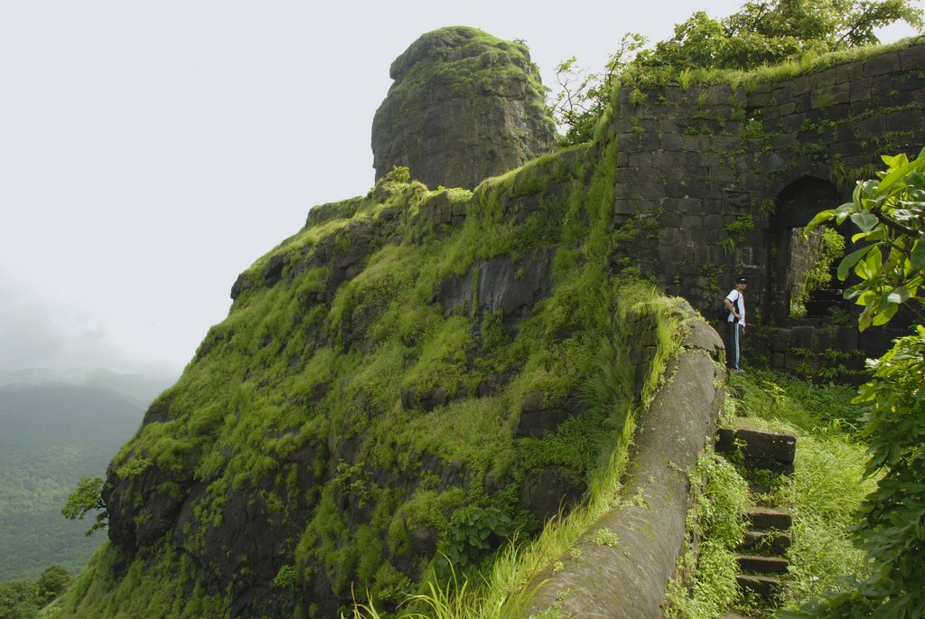
The steps leading up to the fort were cut into the rock of the hill, a very impressive feat.  
If this geological formation was present in many other countries it would be fenced off and no one would be allowed to climb it.  
Kalvantin Durg is also called the Climb to Heaven. No rail on the edge and no ropes on the wall, God forbid if you have vertigo. Worst of all, the hardest part is coming down.  
At the top of Kalavantin Durg you can see the Peb, Chanderi, Matheran, Karnala, and Ershal forts.  
The city of Mumbai itself can also be seen. It is believed that the Fort was built around the time of Buddha or around or before 500 BCE.  
The surrounding terrain is extremely rugged with sharp peaks. This fort was established centuries ago. 
Climb stairs narrow peaks, steep slopes as challenges for visitors. 
Kalavantin worthy Durg fort is considered the most dangerous in the world.
Image result for kalavantin durg history

At a height of 2300 feet, Kalavantin Durg is yet another high peak in Maharashtra that beckons enthusiastic trekkers. It’s an uphill climb and takes around three and a half hours for one to scale and reach the peak. Making your way, through a road which runs a little away from the base village- Thakurwadi you begin with the snaky road that leaps and bounds and leads you to the peak.

If you are travelling from Bandra you can take the first train out to VT that leaves at 4:10 am or the one after that at around 4:30 am and get off at Vadala station. From Vadala station you can board the 5:09 am train that leaves for Panvel and reaches at 6:10 am. Once at Panvel, it’s a brisk eight minute walk to the bus depot. Ask around and you can take a bus to the village Thakurwadi, the first bus leaves around half five, followed by another at 7am. While waiting for the bus, you could munch on a quick snack or sip from garam chai and gear up for the long-drawn-out road ahead. The next bus is around 9:40 am, but its best to take the 7am bus and begin your trek early. It’s an hour’s drive to the base village from where you can begin your uphill climb. Its best to take a bus as the fare is INR 18/- only as compared to a local auto where the fare is INR 300/- which can seat four passengers only.


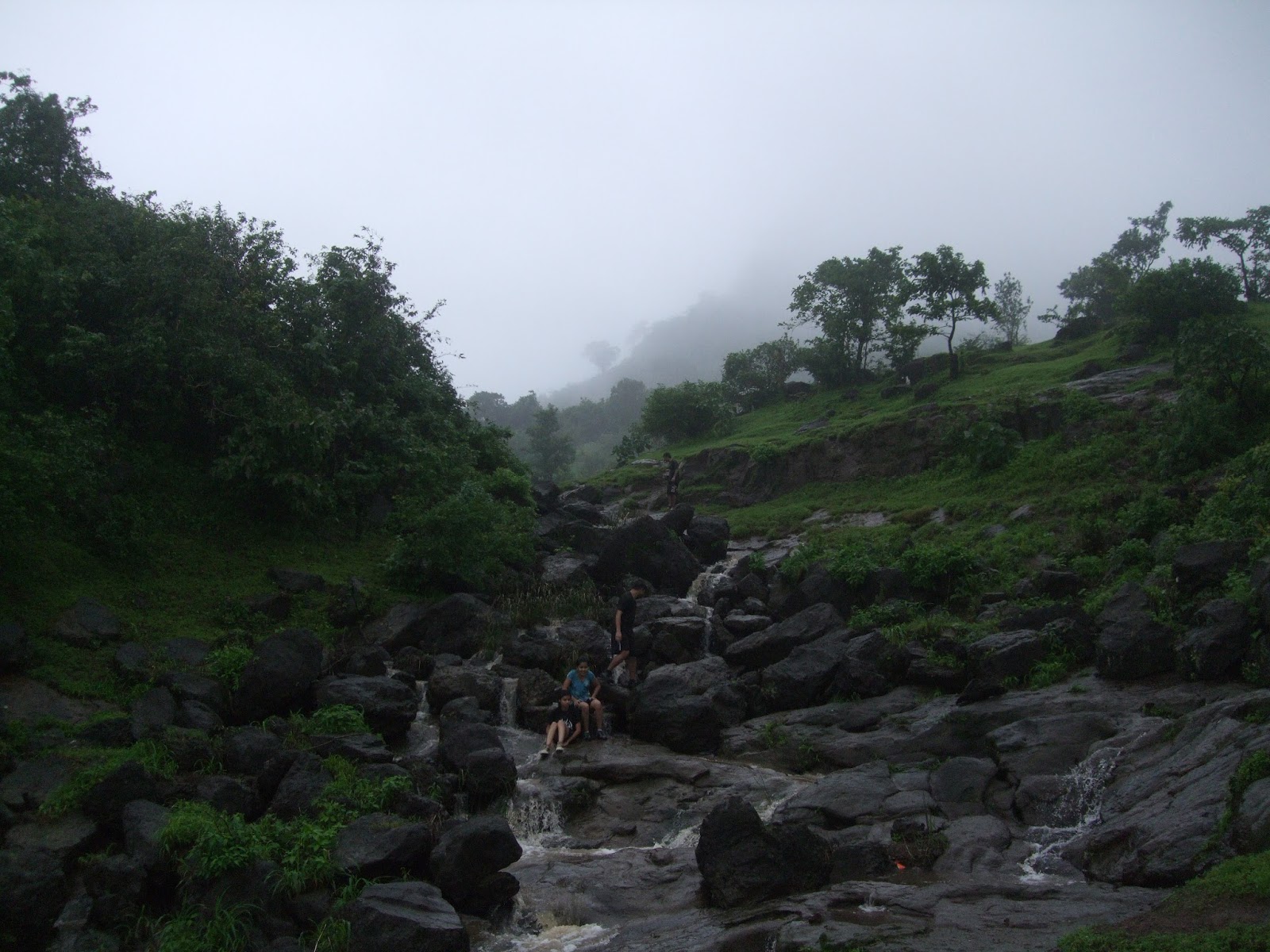
From the base of the village you can spot the two ranges that are spread ahead of you. Prabalgad is one of the peaks and other is Kalavantin Durg. Ask the enthusiastic villagers for direction to the respective peak and they will happily guide you. If you do have a keen and watchful eye for nature you will spot the many bird species, plant varieties and insects that dwell in the lush greenery. 


Once you have trekked for around two hours, you will see a deity carved into a rock and coated with a spray of orange. A little further on and you are in for a treat at a small shack which provides not only chai but also dishes out meals and makes available stay and lodging. You can contact either Namdev K. Bhutanbra on 08451929898 or Balu on 08097089491 or Nilesh on 08056186321 and book your stay if you want to spend your night in the lap of nature and enjoy the breathtaking view all around you. They also have their own website and well written blog that you can research for more details. (website: prabalgad.jigsy.com or  Blog: prabalgad.blogspot.com)

The best time to trek is around June to Jan. One can trek during the monsoons and enjoy the sudden burst of showers or during the cool winters and experience the blowy winds. Although trekking during the monsoon is a bit risky as the path all along has patches of loose mud and rolling stones. Stop along the way at the many streams and baby waterfalls and splash on some chilly water to freshen up or just take a quick dip and laze around in the flowing waters for a while.


As you continue your walk through the muddy and rocky path, you will begin to see more of Kalavantin Durg which makes it seem you have lots more to accomplish. But another hour and a half and you are ascending the never ending flight of stairs.

The zigzag flight of stairs that are cut into the hill are also laden with moss, which make the climb risky and knotty.  You need to ensure your hands are free and you have something to hold on too while ascending the peak. Once you have ascended the peak its sheer pride and happiness and a moment of triumph.


 A trek certainly not for amateurs but for those to like to make their way along the treks least treaded upon. There are also buses that ply along and leave from Thakurwadi to Panvel at 5, 6, 7 and 8pm.

Happy trekking!